


iNavX
Marine Navigation

Beschreibung von iNavX: Marine Navigation
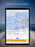
Die Navigation auf See wird mit iNavX – dem weltweit führenden tragbaren Kartenplotter – ganz einfach. Greifen Sie auf Seekarten, Karten, Wetter, AIS und mehr zu!
iNavX ist die einzige App, die Ihnen eine vollständige weltweite Kartenabdeckung bietet, von all Ihren bevorzugten Kartenanbietern, einschließlich der BRANDNEUEN iNavX Professional+ Global Chart! iNavX ist mit One-Touch-Zugriff vollständig aktiviert und bietet Benutzern Zugriff auf die breiteste Auswahl an Seekarten und -karten von mehreren Anbietern, darunter:
• iNavX Professional+-Karten
• Blauer Breitengrad
• Entdecker
• Ihr Wetter
• Wasserstraßenführer
• … und mehr
Wie bringt iNavX die Handheld-Marinenavigation auf die nächste Stufe?
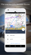
• Segler - Planen Sie Segelrouten mit Wegpunkt- und Routenverwaltung. Holen Sie sich proaktives Segelmanagement mit GRIB-Wettervorhersagen und behalten Sie dann mit AIS-Overlays und der Integration in Ihre Bordsysteme im Auge. Außerdem können Sie sich an Ihre großartigen Segelorte erinnern, indem Sie Fotos mit Geotags versehen.
• Bootsfahrer – Bleiben Sie mit Vorhersagen zu Strömungen, Winden und Wellengang über die Bootsbedingungen auf dem Laufenden. Verwalten Sie Ihre Bootsausrüstung mit nautischer Instrumentenintegration und speichern Sie dann großartige Bootsrouten, um sie mit dem Tracklog zu teilen.
• Angler – Entdecken Sie neue Angelplätze, indem Sie Löcher und Buchten auskundschaften. Finden Sie die besten Angelbedingungen, indem Sie Kaltfronten identifizieren, und speichern Sie Ihre besten Angelplätze mit unbegrenzten Markierungen.
Erweiterte Funktionen - iNavX ist die funktionsreichste App für alle Segel- und Bootsbedürfnisse zu einem günstigen Preis:
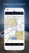
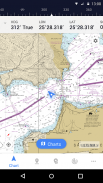
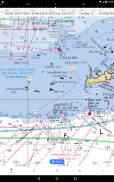
Erweiterter Kartenplotter
• Plotten Sie Ihre Position in Echtzeit mit dem integrierten GPS Ihres Geräts
• Diagramme schwenken, zoomen und drehen (einschließlich Kurs nach oben)
• Drucken Sie detaillierte Diagramme zur Verwendung in Kombination mit der App
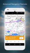
Erweiterte Navigation
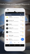
• Erstellen Sie Wegpunkte und planen Sie Routen, um zwischen ihnen zu navigieren
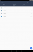
• Track Log ermöglicht es Ihnen, Ihre Route aufzuzeichnen
• Daten im KML- (Google Earth) oder GPX-Format importieren/exportieren
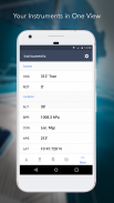
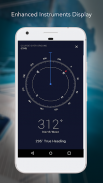
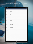
Fortgeschrittene Instrumentierung
• Unterstützt NMEA-Daten über TCP/IP (mit WLAN)
• Integration mit externen GPS-, AIS-Empfängern und Transpondern
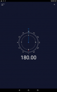
• Verbinden Sie nautische Instrumente: Tiefe, Geschwindigkeit, Wind, Motor, Batterien usw.
Wesentliches Toolkit
• GRIB-Wettervorhersage
• Gezeiten/Strömungen
• Ankeralarm
• AIS-Integration
• Hafen-/Navaid-Suche
Laden Sie iNavX noch HEUTE herunter und erhalten Sie automatisch eine kostenlose Kopie der offiziellen und aktuellen hochauflösenden NOAA RNC-Marine-Rasterkarten der Vereinigten Staaten.
BEWERTUNGEN
„iNavX ist das Original und immer noch eine der besten Navigations-Apps.“
– Praktischer Segler
„Die umfassendste Navigations-App, die es gibt und die von vielen als Standard angesehen wird“
– Segelmagazin
„Die Nr. 1 der empfohlenen Seekarten-Apps“
- iMarineApps
iNavX ist kompatibel mit: C-MAP, Theyr Weather, Waterway Guide, AIS, Brookhouse, DigitalYacht, ShipModul, vYacht, Vesper Marine, NMEA 2000, Chetco und mehr.
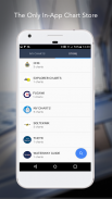
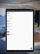
NEUER KARTENSPEICHER
Kaufen Sie alle Ihre Lieblingscharts. Kartenabonnements variieren je nach Karte und Anbieter zwischen 9,99 $ und 199,99 $ pro Jahr und werden Ihrem iTunes-Konto belastet, das automatisch verlängert wird, wenn es nicht mindestens 24 Stunden vor dem Ende des aktuellen Zeitraums gekündigt wird. Die automatische Verlängerung kann jederzeit deaktiviert werden, indem Sie nach dem Kauf zu Ihren Kontoeinstellungen in iTunes gehen. Während des aktiven Abonnementzeitraums ist keine Kündigung des aktuellen Abonnements zulässig.
HINWEIS: Die fortgesetzte Verwendung von GPS im Hintergrund kann die Batterielebensdauer drastisch verringern.
MEHR INFO
Website: http://inavx.com/
Benutzerhandbuch: http://inavx.com/help/
Nutzungsbedingungen: http://inavx.com/terms
Datenschutzrichtlinie: http://inavx.com/privacy
iNavX: Marine Navigation – Version 1.6.6
(03-08-2024)
iNavX: Marine Navigation – APK Informationen
APK Version: 1.6.6Paket: com.gpsnavx.iNavXNeueste Version von iNavX: Marine Navigation
Weitere Versionen


Apps in derselben Kategorie


Das könnte dir auch gefallen...


